


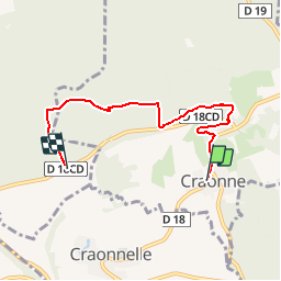
Craonne 4.7 km

GOELERANDO2
User

Length
4.7 km

Max alt
195 m

Uphill gradient
152 m
Km-Effort
6.4 km

Min alt
85 m

Downhill gradient
47 m
Boucle
No
Creation date :
2018-04-17 18:05:27.315
Updated on :
2018-04-17 18:05:27.315
1h29
Difficulty : Easy

FREE GPS app for hiking
 SityTrail
IGN / Geographical institutes
SityTrail Plus
The world is yours!
About
Trail Walking of 4.7 km to be discovered at Hauts-de-France, Aisne, Craonne. This trail is proposed by GOELERANDO2.
Description
Départ du centre ville de Craonne vers le plateau de Californie.
Positioning
Country:
France
Region :
Hauts-de-France
Department/Province :
Aisne
Municipality :
Craonne
Location:
Unknown
Start:(Dec)
Start:(UTM)
556994 ; 5476614 (31U) N.
Comments