


THOMERY - FONTAINEBLEAU

NUITEVEN
User
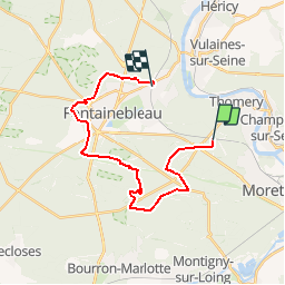

Length
21 km

Max alt
134 m

Uphill gradient
275 m
Km-Effort
25 km

Min alt
74 m

Downhill gradient
290 m
Boucle
No
Creation date :
2018-04-17 18:10:54.855
Updated on :
2018-04-17 18:10:54.855
5h23
Difficulty : Very easy

FREE GPS app for hiking
 SityTrail
IGN / Geographical institutes
SityTrail Plus
The world is yours!
About
Trail Walking of 21 km to be discovered at Ile-de-France, Seine-et-Marne, Fontainebleau. This trail is proposed by NUITEVEN.
Positioning
Country:
France
Region :
Ile-de-France
Department/Province :
Seine-et-Marne
Municipality :
Fontainebleau
Location:
Unknown
Start:(Dec)
Start:(UTM)
482537 ; 5360118 (31U) N.
Comments