


tour queyroig

rene06530
User
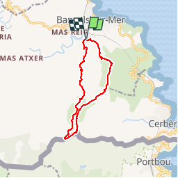

Length
12.1 km

Max alt
651 m

Uphill gradient
701 m
Km-Effort
21 km

Min alt
13 m

Downhill gradient
699 m
Boucle
Yes
Creation date :
2018-04-17 18:21:50.461
Updated on :
2018-04-17 18:21:50.461
5h55
Difficulty : Difficult

FREE GPS app for hiking
 SityTrail
IGN / Geographical institutes
SityTrail Plus
The world is yours!
About
Trail Walking of 12.1 km to be discovered at Occitania, Pyrénées-Orientales, Banyuls-sur-Mer. This trail is proposed by rene06530.
Positioning
Country:
France
Region :
Occitania
Department/Province :
Pyrénées-Orientales
Municipality :
Banyuls-sur-Mer
Location:
Unknown
Start:(Dec)
Start:(UTM)
510336 ; 4702178 (31T) N.
Comments