


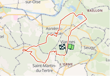
*Viarmes, Royaumont et la forêt de Carnelle

jpcccb
User

Length
17.9 km

Max alt
219 m

Uphill gradient
338 m
Km-Effort
22 km

Min alt
24 m

Downhill gradient
336 m
Boucle
Yes
Creation date :
2018-04-17 18:39:19.912
Updated on :
2023-05-11 15:16:32.817
5h06
Difficulty : Very difficult

FREE GPS app for hiking
 SityTrail
IGN / Geographical institutes
SityTrail Plus
The world is yours!
About
Trail Walking of 17.9 km to be discovered at Ile-de-France, Val-d'Oise, Viarmes. This trail is proposed by jpcccb.
Description
Abbaye de Royaumont- Forêt de Carnelle- Lac bleu- Petit étang- Tour de St Martin du Tertre.


Positioning
Country:
France
Region :
Ile-de-France
Department/Province :
Val-d'Oise
Municipality :
Viarmes
Location:
Unknown
Start:(Dec)
Start:(UTM)
453892 ; 5440666 (31U) N.
Comments