


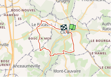
Boucle Clères par le Bocasse

kikidenis1
User

Length
11.2 km

Max alt
185 m

Uphill gradient
219 m
Km-Effort
14.1 km

Min alt
73 m

Downhill gradient
220 m
Boucle
Yes
Creation date :
2018-04-17 18:39:57.059
Updated on :
2018-04-17 18:39:57.059
3h02
Difficulty : Easy

FREE GPS app for hiking
 SityTrail
IGN / Geographical institutes
SityTrail Plus
The world is yours!
About
Trail Walking of 11.2 km to be discovered at Normandy, Seine-Maritime, Clères. This trail is proposed by kikidenis1.
Positioning
Country:
France
Region :
Normandy
Department/Province :
Seine-Maritime
Municipality :
Clères
Location:
Unknown
Start:(Dec)
Start:(UTM)
363477 ; 5495584 (31U) N.
Comments