


Villeneuve les avignon

ramsay
User
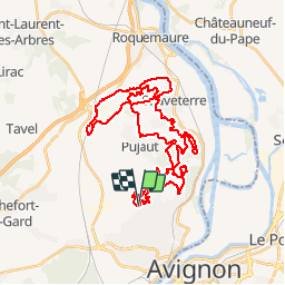

Length
46 km

Max alt
138 m

Uphill gradient
761 m
Km-Effort
56 km

Min alt
23 m

Downhill gradient
762 m
Boucle
Yes
Creation date :
2018-04-17 19:03:35.89
Updated on :
2018-04-17 19:03:35.89
3h34
Difficulty : Difficult

FREE GPS app for hiking
 SityTrail
IGN / Geographical institutes
SityTrail Plus
The world is yours!
About
Trail Mountain bike of 46 km to be discovered at Occitania, Gard, Villeneuve-lès-Avignon. This trail is proposed by ramsay.
Positioning
Country:
France
Region :
Occitania
Department/Province :
Gard
Municipality :
Villeneuve-lès-Avignon
Location:
Unknown
Start:(Dec)
Start:(UTM)
642115 ; 4870873 (31T) N.
Comments