


Circuit de Villery

eric.deniau
User
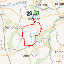

Length
9.1 km

Max alt
76 m

Uphill gradient
90 m
Km-Effort
10.3 km

Min alt
19 m

Downhill gradient
88 m
Boucle
Yes
Creation date :
2018-04-17 19:10:02.377
Updated on :
2018-04-17 19:10:02.377
2h16
Difficulty : Easy

FREE GPS app for hiking
 SityTrail
IGN / Geographical institutes
SityTrail Plus
The world is yours!
About
Trail Walking of 9.1 km to be discovered at Brittany, Ille-et-Vilaine, Trévérien. This trail is proposed by eric.deniau.
Positioning
Country:
France
Region :
Brittany
Department/Province :
Ille-et-Vilaine
Municipality :
Trévérien
Location:
Unknown
Start:(Dec)
Start:(UTM)
579309 ; 5358124 (30U) N.
Comments