


ajustin@laposte.net sur sys-cobonne

okfred26
User
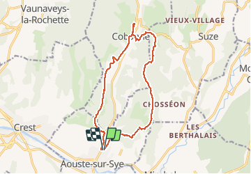

Length
15.7 km

Max alt
463 m

Uphill gradient
458 m
Km-Effort
22 km

Min alt
216 m

Downhill gradient
463 m
Boucle
Yes
Creation date :
2018-04-17 19:21:23.972
Updated on :
2018-07-31 16:07:48.546
5h48
Difficulty : Unknown

FREE GPS app for hiking
 SityTrail
IGN / Geographical institutes
SityTrail Plus
The world is yours!
About
Trail Walking of 15.7 km to be discovered at Auvergne-Rhône-Alpes, Drôme, Aouste-sur-Sye. This trail is proposed by okfred26.
Positioning
Country:
France
Region :
Auvergne-Rhône-Alpes
Department/Province :
Drôme
Municipality :
Aouste-sur-Sye
Location:
Unknown
Start:(Dec)
Start:(UTM)
663382 ; 4953981 (31T) N.
Comments