


Sanguinet, port de l'Estey

papiou
User
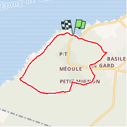

Length
6.9 km

Max alt
38 m

Uphill gradient
55 m
Km-Effort
7.7 km

Min alt
23 m

Downhill gradient
56 m
Boucle
Yes
Creation date :
2018-04-17 19:38:52.891
Updated on :
2018-04-17 19:38:52.891
1h58
Difficulty : Easy

FREE GPS app for hiking
 SityTrail
IGN / Geographical institutes
SityTrail Plus
The world is yours!
About
Trail Walking of 6.9 km to be discovered at New Aquitaine, Landes, Sanguinet. This trail is proposed by papiou.
Description
Rdv parking du port de l'Estey, dos au lac prendre à gauche et 200 mètres plus loin pénétrer dans le bois et suivre balisage bien fait
Positioning
Country:
France
Region :
New Aquitaine
Department/Province :
Landes
Municipality :
Sanguinet
Location:
Unknown
Start:(Dec)
Start:(UTM)
650874 ; 4927057 (30T) N.
Comments