


circuit des trois foret

thle
User
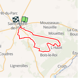

Length
22 km

Max alt
151 m

Uphill gradient
202 m
Km-Effort
25 km

Min alt
79 m

Downhill gradient
202 m
Boucle
Yes
Creation date :
2018-04-17 19:48:33.523
Updated on :
2018-04-17 19:48:33.523
3h06
Difficulty : Medium

FREE GPS app for hiking
 SityTrail
IGN / Geographical institutes
SityTrail Plus
The world is yours!
About
Trail Equestrian of 22 km to be discovered at Normandy, Eure, Saint-André-de-l'Eure. This trail is proposed by thle.


Positioning
Country:
France
Region :
Normandy
Department/Province :
Eure
Municipality :
Saint-André-de-l'Eure
Location:
Unknown
Start:(Dec)
Start:(UTM)
373925 ; 5418346 (31U) N.
Comments