


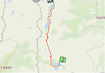
Refuge merveilles- Refuge de valmasque

GDE
User

Length
8.5 km

Max alt
2557 m

Uphill gradient
469 m
Km-Effort
14.4 km

Min alt
2122 m

Downhill gradient
374 m
Boucle
No
Creation date :
2019-02-19 19:22:45.432
Updated on :
2019-02-19 19:22:45.452
3h09
Difficulty : Medium

FREE GPS app for hiking
 SityTrail
IGN / Geographical institutes
SityTrail Plus
The world is yours!
About
Trail Walking of 8.5 km to be discovered at Provence-Alpes-Côte d'Azur, Maritime Alps, Tende. This trail is proposed by GDE.
Positioning
Country:
France
Region :
Provence-Alpes-Côte d'Azur
Department/Province :
Maritime Alps
Municipality :
Tende
Location:
Unknown
Start:(Dec)
Start:(UTM)
376004 ; 4879413 (32T) N.
Comments