


eneo fromelennes

fra_depoorter
User
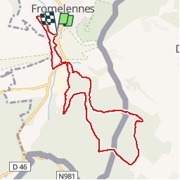

Length
9 km

Max alt
314 m

Uphill gradient
231 m
Km-Effort
12.1 km

Min alt
109 m

Downhill gradient
229 m
Boucle
Yes
Creation date :
2018-04-17 20:02:15.097
Updated on :
2018-04-17 20:02:15.097
2h18
Difficulty : Unknown

FREE GPS app for hiking
 SityTrail
IGN / Geographical institutes
SityTrail Plus
The world is yours!
About
Trail Other activity of 9 km to be discovered at Grand Est, Ardennes, Fromelennes. This trail is proposed by fra_depoorter.
Positioning
Country:
France
Region :
Grand Est
Department/Province :
Ardennes
Municipality :
Fromelennes
Location:
Unknown
Start:(Dec)
Start:(UTM)
632705 ; 5553591 (31U) N.
Comments