


VERNEUIL L'ETANG - SIVRY-COURTRY

NUITEVEN
User
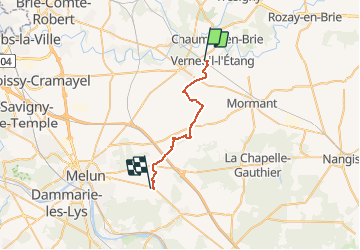

Length
21 km

Max alt
102 m

Uphill gradient
125 m
Km-Effort
23 km

Min alt
65 m

Downhill gradient
131 m
Boucle
No
Creation date :
2018-04-17 20:02:55.152
Updated on :
2020-01-18 17:07:21.12
6h18
Difficulty : Unknown

FREE GPS app for hiking
 SityTrail
IGN / Geographical institutes
SityTrail Plus
The world is yours!
About
Trail Walking of 21 km to be discovered at Ile-de-France, Seine-et-Marne, Verneuil-l'Étang. This trail is proposed by NUITEVEN.
Positioning
Country:
France
Region :
Ile-de-France
Department/Province :
Seine-et-Marne
Municipality :
Verneuil-l'Étang
Location:
Unknown
Start:(Dec)
Start:(UTM)
487093 ; 5388010 (31U) N.
Comments