


les 3 lacs Graulhet

papiou
User

Length
8.5 km

Max alt
269 m

Uphill gradient
215 m
Km-Effort
11.3 km

Min alt
175 m

Downhill gradient
212 m
Boucle
Yes
Creation date :
2018-04-17 20:03:23.03
Updated on :
2018-04-17 20:03:23.03
2h05
Difficulty : Difficult

FREE GPS app for hiking
 SityTrail
IGN / Geographical institutes
SityTrail Plus
The world is yours!
About
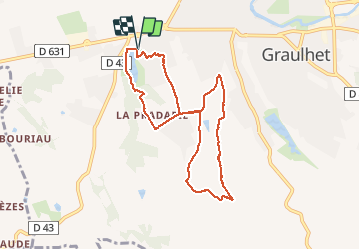
Trail Walking of 8.5 km to be discovered at Occitania, Tarn, Graulhet. This trail is proposed by papiou.
Description
Rdv parking du lac nabeillou et suivre fléchage très visible. Attention à un endroit passage du circuit dans les 2 sens
Photos


Positioning
Country:
France
Region :
Occitania
Department/Province :
Tarn
Municipality :
Graulhet
Location:
Unknown
Start:(Dec)
Start:(UTM)
417106 ; 4845544 (31T) N.
Comments