


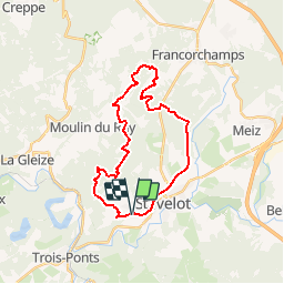
PARFONDRY 23KM

ochelen
User

Length
23 km

Max alt
524 m

Uphill gradient
649 m
Km-Effort
32 km

Min alt
300 m

Downhill gradient
646 m
Boucle
Yes
Creation date :
2018-04-17 20:23:10.225
Updated on :
2018-04-17 20:23:10.225
55m
Difficulty : Medium

FREE GPS app for hiking
 SityTrail
IGN / Geographical institutes
SityTrail Plus
The world is yours!
About
Trail Equestrian of 23 km to be discovered at Wallonia, Liège, Stavelot. This trail is proposed by ochelen.

Positioning
Country:
Belgium
Region :
Wallonia
Department/Province :
Liège
Municipality :
Stavelot
Location:
Stavelot
Start:(Dec)
Start:(UTM)
706994 ; 5585999 (31U) N.
Comments