


STAVELOT

ochelen
User
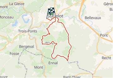

Length
25 km

Max alt
579 m

Uphill gradient
621 m
Km-Effort
34 km

Min alt
274 m

Downhill gradient
694 m
Boucle
No
Creation date :
2018-04-17 20:23:12.44
Updated on :
2018-04-17 20:23:12.44
1h20
Difficulty : Medium

FREE GPS app for hiking
 SityTrail
IGN / Geographical institutes
SityTrail Plus
The world is yours!
About
Trail Equestrian of 25 km to be discovered at Wallonia, Liège, Stavelot. This trail is proposed by ochelen.

Positioning
Country:
Belgium
Region :
Wallonia
Department/Province :
Liège
Municipality :
Stavelot
Location:
Stavelot
Start:(Dec)
Start:(UTM)
706997 ; 5585998 (31U) N.
Comments