


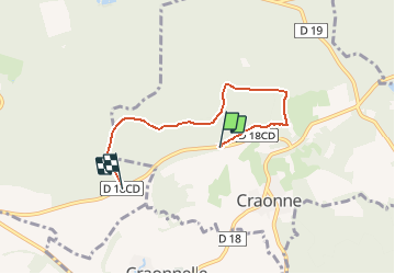
Plateau de Californie 4.4 KM

GOELERANDO2
User


1h18
Difficulty : Medium

FREE GPS app for hiking
 SityTrail
IGN / Geographical institutes
SityTrail Plus
The world is yours!
About
Trail Walking of 4.4 km to be discovered at Hauts-de-France, Aisne, Craonne. This trail is proposed by GOELERANDO2.
Description
Départ de la tour d'Orientation sur le CD
Départ de la Tour d'Orientation sur le D18CD
Arrivée au monument Napoléon.
Positioning
Comments