


Taizé Mt St Romain Rémy 4 mars

yakout
User
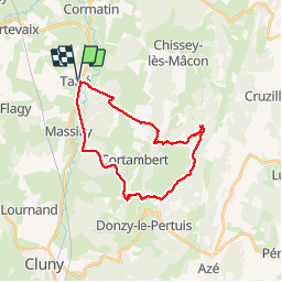

Length
24 km

Max alt
571 m

Uphill gradient
681 m
Km-Effort
33 km

Min alt
210 m

Downhill gradient
683 m
Boucle
Yes
Creation date :
2018-04-17 20:54:01.116
Updated on :
2018-04-17 20:54:01.116
6h12
Difficulty : Unknown

FREE GPS app for hiking
 SityTrail
IGN / Geographical institutes
SityTrail Plus
The world is yours!
About
Trail Walking of 24 km to be discovered at Bourgogne-Franche-Comté, Saône-et-Loire, Taizé. This trail is proposed by yakout.


Positioning
Country:
France
Region :
Bourgogne-Franche-Comté
Department/Province :
Saône-et-Loire
Municipality :
Taizé
Location:
Unknown
Start:(Dec)
Start:(UTM)
628837 ; 5152339 (31T) N.
Comments