


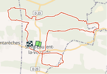
st laurent la vernede

losjo
User

Length
16.1 km

Max alt
296 m

Uphill gradient
266 m
Km-Effort
19.6 km

Min alt
169 m

Downhill gradient
266 m
Boucle
Yes
Creation date :
2018-04-17 20:59:41.444
Updated on :
2018-04-17 20:59:41.444
4h30
Difficulty : Easy

FREE GPS app for hiking
 SityTrail
IGN / Geographical institutes
SityTrail Plus
The world is yours!
About
Trail Walking of 16.1 km to be discovered at Occitania, Gard, Saint-Laurent-la-Vernède. This trail is proposed by losjo.
Positioning
Country:
France
Region :
Occitania
Department/Province :
Gard
Municipality :
Saint-Laurent-la-Vernède
Location:
Unknown
Start:(Dec)
Start:(UTM)
616338 ; 4884699 (31T) N.
Comments