


boucle euffigneix

carolineF11
User
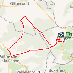

Length
16.1 km

Max alt
378 m

Uphill gradient
265 m
Km-Effort
19.7 km

Min alt
249 m

Downhill gradient
263 m
Boucle
Yes
Creation date :
2018-04-17 21:01:18.295
Updated on :
2018-04-17 21:01:18.295
5h00
Difficulty : Medium

FREE GPS app for hiking
 SityTrail
IGN / Geographical institutes
SityTrail Plus
The world is yours!
About
Trail Walking of 16.1 km to be discovered at Grand Est, Haute-Marne, Euffigneix. This trail is proposed by carolineF11.
Description
non testé
Positioning
Country:
France
Region :
Grand Est
Department/Province :
Haute-Marne
Municipality :
Euffigneix
Location:
Unknown
Start:(Dec)
Start:(UTM)
652259 ; 5332777 (31U) N.
Comments