


Sommet de Javanon

rigol05
User

Length
13.8 km

Max alt
865 m

Uphill gradient
422 m
Km-Effort
19.4 km

Min alt
641 m

Downhill gradient
421 m
Boucle
Yes
Creation date :
2018-04-17 21:20:18.929
Updated on :
2018-04-17 21:20:18.929
4h02
Difficulty : Medium

FREE GPS app for hiking
 SityTrail
IGN / Geographical institutes
SityTrail Plus
The world is yours!
About
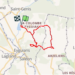
Trail Walking of 13.8 km to be discovered at Provence-Alpes-Côte d'Azur, Hautes-Alpes, Garde-Colombe. This trail is proposed by rigol05.
Description
Sortie du 08/03/2018
Positioning
Country:
France
Region :
Provence-Alpes-Côte d'Azur
Department/Province :
Hautes-Alpes
Municipality :
Garde-Colombe
Location:
Eyguians
Start:(Dec)
Start:(UTM)
720812 ; 4916406 (31T) N.
Comments