


41. plan de la mouille

lolo04
User
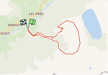

Length
7.5 km

Max alt
1961 m

Uphill gradient
852 m
Km-Effort
18.9 km

Min alt
1158 m

Downhill gradient
849 m
Boucle
Yes
Creation date :
2018-04-17 21:22:41.04
Updated on :
2018-04-17 21:22:41.04
5h50
Difficulty : Medium

FREE GPS app for hiking
 SityTrail
IGN / Geographical institutes
SityTrail Plus
The world is yours!
About
Trail Snowshoes of 7.5 km to be discovered at Auvergne-Rhône-Alpes, Savoy, Hauteluce. This trail is proposed by lolo04.
Positioning
Country:
France
Region :
Auvergne-Rhône-Alpes
Department/Province :
Savoy
Municipality :
Hauteluce
Location:
Unknown
Start:(Dec)
Start:(UTM)
314334 ; 5069882 (32T) N.
Comments