


Abbaye de Jouarre 15.2 km

GOELERANDO2
User
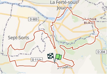

Length
15.2 km

Max alt
152 m

Uphill gradient
274 m
Km-Effort
18.8 km

Min alt
51 m

Downhill gradient
274 m
Boucle
Yes
Creation date :
2018-04-17 21:23:19.911
Updated on :
2018-04-17 21:23:19.911
2h12
Difficulty : Difficult

FREE GPS app for hiking
 SityTrail
IGN / Geographical institutes
SityTrail Plus
The world is yours!
About
Trail Walking of 15.2 km to be discovered at Ile-de-France, Seine-et-Marne, Jouarre. This trail is proposed by GOELERANDO2.
Description
Parking et départ du cimetière de Jouarre.
Positioning
Country:
France
Region :
Ile-de-France
Department/Province :
Seine-et-Marne
Municipality :
Jouarre
Location:
Unknown
Start:(Dec)
Start:(UTM)
509053 ; 5419428 (31U) N.
Comments