


salledes

jeanic63
User
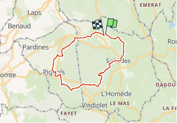

Length
14.1 km

Max alt
717 m

Uphill gradient
375 m
Km-Effort
19.1 km

Min alt
565 m

Downhill gradient
397 m
Boucle
Yes
Creation date :
2018-04-17 21:31:20.714
Updated on :
2021-04-11 13:18:23.219
3h25
Difficulty : Unknown

FREE GPS app for hiking
 SityTrail
IGN / Geographical institutes
SityTrail Plus
The world is yours!
About
Trail Other activity of 14.1 km to be discovered at Auvergne-Rhône-Alpes, Puy-de-Dôme, Sallèdes. This trail is proposed by jeanic63.
Description
départ château de la chaux montgros
Positioning
Country:
France
Region :
Auvergne-Rhône-Alpes
Department/Province :
Puy-de-Dôme
Municipality :
Sallèdes
Location:
Unknown
Start:(Dec)
Start:(UTM)
524872 ; 5056675 (31T) N.
Comments