


Cazedarnes

jdelettrez
User
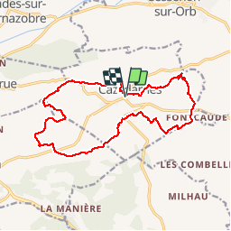

Length
17.4 km

Max alt
242 m

Uphill gradient
311 m
Km-Effort
22 km

Min alt
93 m

Downhill gradient
311 m
Boucle
Yes
Creation date :
2018-04-17 22:04:54.875
Updated on :
2018-04-17 22:04:54.875
4h39
Difficulty : Difficult

FREE GPS app for hiking
 SityTrail
IGN / Geographical institutes
SityTrail Plus
The world is yours!
About
Trail Walking of 17.4 km to be discovered at Occitania, Hérault, Cazedarnes. This trail is proposed by jdelettrez.


Positioning
Country:
France
Region :
Occitania
Department/Province :
Hérault
Municipality :
Cazedarnes
Location:
Unknown
Start:(Dec)
Start:(UTM)
502254 ; 4807846 (31T) N.
Comments