


bosc feret

thle
User
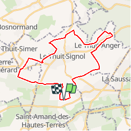

Length
16.3 km

Max alt
168 m

Uphill gradient
136 m
Km-Effort
18.1 km

Min alt
120 m

Downhill gradient
137 m
Boucle
Yes
Creation date :
2018-04-17 22:08:33.879
Updated on :
2018-04-17 22:08:33.879
2h18
Difficulty : Easy

FREE GPS app for hiking
 SityTrail
IGN / Geographical institutes
SityTrail Plus
The world is yours!
About
Trail Equestrian of 16.3 km to be discovered at Normandy, Eure, Le Thuit-de-l'Oison. This trail is proposed by thle.
Positioning
Country:
France
Region :
Normandy
Department/Province :
Eure
Municipality :
Le Thuit-de-l'Oison
Location:
Unknown
Start:(Dec)
Start:(UTM)
350131 ; 5456854 (31U) N.
Comments