


Thèze Sigoyer

rigol05
User
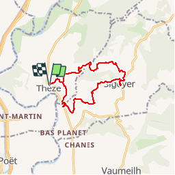

Length
13.3 km

Max alt
824 m

Uphill gradient
357 m
Km-Effort
18 km

Min alt
519 m

Downhill gradient
357 m
Boucle
Yes
Creation date :
2018-04-17 22:19:16.873
Updated on :
2018-04-17 22:19:16.873
3h50
Difficulty : Medium

FREE GPS app for hiking
 SityTrail
IGN / Geographical institutes
SityTrail Plus
The world is yours!
About
Trail Walking of 13.3 km to be discovered at Provence-Alpes-Côte d'Azur, Alpes-de-Haute-Provence, Thèze. This trail is proposed by rigol05.
Description
Sortie du 19/03/2018Itinéraire dévié,torrent infranchissable (trop d'eau)Gué traversé en déchaussant.
Positioning
Country:
France
Region :
Provence-Alpes-Côte d'Azur
Department/Province :
Alpes-de-Haute-Provence
Municipality :
Thèze
Location:
Unknown
Start:(Dec)
Start:(UTM)
733030 ; 4911470 (31T) N.
Comments