


col de la croix

losjo
User
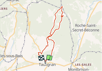

Length
16.2 km

Max alt
708 m

Uphill gradient
520 m
Km-Effort
23 km

Min alt
273 m

Downhill gradient
521 m
Boucle
Yes
Creation date :
2018-04-17 22:29:02.219
Updated on :
2018-04-17 22:29:02.219
6h39
Difficulty : Medium

FREE GPS app for hiking
 SityTrail
IGN / Geographical institutes
SityTrail Plus
The world is yours!
About
Trail Walking of 16.2 km to be discovered at Auvergne-Rhône-Alpes, Drôme, Taulignan. This trail is proposed by losjo.
Positioning
Country:
France
Region :
Auvergne-Rhône-Alpes
Department/Province :
Drôme
Municipality :
Taulignan
Location:
Unknown
Start:(Dec)
Start:(UTM)
657486 ; 4923094 (31T) N.
Comments