


bandol les lecques

losjo
User
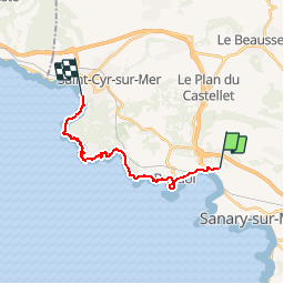

Length
15.8 km

Max alt
95 m

Uphill gradient
336 m
Km-Effort
20 km

Min alt
-3 m

Downhill gradient
376 m
Boucle
No
Creation date :
2018-04-17 22:29:24.54
Updated on :
2018-04-17 22:29:24.54
4h32
Difficulty : Medium

FREE GPS app for hiking
 SityTrail
IGN / Geographical institutes
SityTrail Plus
The world is yours!
About
Trail Walking of 15.8 km to be discovered at Provence-Alpes-Côte d'Azur, Var, Sanary-sur-Mer. This trail is proposed by losjo.


Positioning
Country:
France
Region :
Provence-Alpes-Côte d'Azur
Department/Province :
Var
Municipality :
Sanary-sur-Mer
Location:
Unknown
Start:(Dec)
Start:(UTM)
726069 ; 4780159 (31T) N.
Comments