


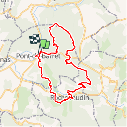
rochebaudin et pont de baret

raygautier
User

Length
19.4 km

Max alt
650 m

Uphill gradient
786 m
Km-Effort
30 km

Min alt
237 m

Downhill gradient
776 m
Boucle
No
Creation date :
2018-04-17 22:51:07.027
Updated on :
2018-04-17 22:51:07.027
5h09
Difficulty : Easy

FREE GPS app for hiking
 SityTrail
IGN / Geographical institutes
SityTrail Plus
The world is yours!
About
Trail Walking of 19.4 km to be discovered at Auvergne-Rhône-Alpes, Drôme, Pont-de-Barret. This trail is proposed by raygautier.
Positioning
Country:
France
Region :
Auvergne-Rhône-Alpes
Department/Province :
Drôme
Municipality :
Pont-de-Barret
Location:
Unknown
Start:(Dec)
Start:(UTM)
659474 ; 4940567 (31T) N.
Comments