


la rosinette chambly

anonymous_fa1aecfc15
User
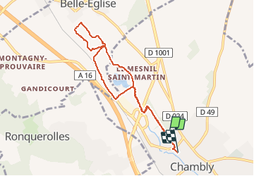

Length
7.6 km

Max alt
54 m

Uphill gradient
66 m
Km-Effort
8.5 km

Min alt
34 m

Downhill gradient
67 m
Boucle
No
Creation date :
2018-04-17 22:51:11.583
Updated on :
2018-04-17 22:51:11.583
1h56
Difficulty : Very easy

FREE GPS app for hiking
 SityTrail
IGN / Geographical institutes
SityTrail Plus
The world is yours!
About
Trail Other activity of 7.6 km to be discovered at Hauts-de-France, Oise, Chambly. This trail is proposed by anonymous_fa1aecfc15.
Photos


Positioning
Country:
France
Region :
Hauts-de-France
Department/Province :
Oise
Municipality :
Chambly
Location:
Unknown
Start:(Dec)
Start:(UTM)
444502 ; 5446707 (31U) N.
Comments