


Champniers Blazac Anais

ludol
User
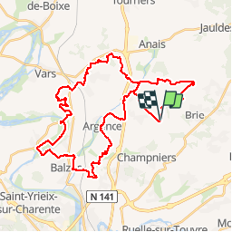

Length
44 km

Max alt
138 m

Uphill gradient
644 m
Km-Effort
52 km

Min alt
32 m

Downhill gradient
640 m
Boucle
Yes
Creation date :
2018-04-17 22:52:34.031
Updated on :
2019-04-24 20:46:01.15
4h17
Difficulty : Difficult

FREE GPS app for hiking
 SityTrail
IGN / Geographical institutes
SityTrail Plus
The world is yours!
About
Trail Mountain bike of 44 km to be discovered at New Aquitaine, Charente, Champniers. This trail is proposed by ludol.
Description
Alternance de passages roulants et de single techniques voire très techniques dans des côteaux. Paysages changeants .
Positioning
Country:
France
Region :
New Aquitaine
Department/Province :
Charente
Municipality :
Champniers
Location:
Unknown
Start:(Dec)
Start:(UTM)
283361 ; 5068281 (31T) N.
Comments