


EC carto 1 Bois le Prêtre

PhilippeC54
User
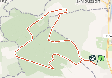

Length
12 km

Max alt
379 m

Uphill gradient
257 m
Km-Effort
15.4 km

Min alt
245 m

Downhill gradient
257 m
Boucle
Yes
Creation date :
2018-04-17 22:56:56.76
Updated on :
2018-04-17 22:56:56.76
1h00
Difficulty : Unknown

FREE GPS app for hiking
 SityTrail
IGN / Geographical institutes
SityTrail Plus
The world is yours!
About
Trail Mountain bike of 12 km to be discovered at Grand Est, Meurthe-et-Moselle, Pont-à-Mousson. This trail is proposed by PhilippeC54.
Description
Parcours dans Bois le Prêtre, copie du CJC de 2016
Positioning
Country:
France
Region :
Grand Est
Department/Province :
Meurthe-et-Moselle
Municipality :
Pont-à-Mousson
Location:
Unknown
Start:(Dec)
Start:(UTM)
282513 ; 5421721 (32U) N.
Comments