


Chambors_Lattainville_Delincourt_Reilly (dolmen) / 16km_290mDEN

philberard95
User
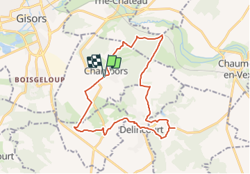

Length
15.8 km

Max alt
152 m

Uphill gradient
288 m
Km-Effort
19.6 km

Min alt
60 m

Downhill gradient
287 m
Boucle
Yes
Creation date :
2018-04-17 23:06:00.801
Updated on :
2021-07-02 16:36:03.971
4h16
Difficulty : Medium

FREE GPS app for hiking
 SityTrail
IGN / Geographical institutes
SityTrail Plus
The world is yours!
About
Trail Walking of 15.8 km to be discovered at Hauts-de-France, Oise, Chambors. This trail is proposed by philberard95.
Positioning
Country:
France
Region :
Hauts-de-France
Department/Province :
Oise
Municipality :
Chambors
Location:
Unknown
Start:(Dec)
Start:(UTM)
413712 ; 5457026 (31U) N.
Comments