


, champagne de meyras saint-pierre de colombier

raab
User
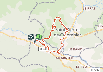

Length
8.3 km

Max alt
656 m

Uphill gradient
324 m
Km-Effort
12.6 km

Min alt
388 m

Downhill gradient
324 m
Boucle
Yes
Creation date :
2018-07-30 16:23:25.826
Updated on :
2018-07-30 16:23:25.846
3h37
Difficulty : Difficult

FREE GPS app for hiking
 SityTrail
IGN / Geographical institutes
SityTrail Plus
The world is yours!
About
Trail Walking of 8.3 km to be discovered at Auvergne-Rhône-Alpes, Ardèche, Meyras. This trail is proposed by raab.
Positioning
Country:
France
Region :
Auvergne-Rhône-Alpes
Department/Province :
Ardèche
Municipality :
Meyras
Location:
Unknown
Start:(Dec)
Start:(UTM)
598330 ; 4950201 (31T) N.
Comments