


DAMERY

bruno38
User
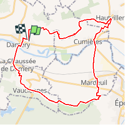

Length
19.1 km

Max alt
219 m

Uphill gradient
431 m
Km-Effort
25 km

Min alt
65 m

Downhill gradient
426 m
Boucle
Yes
Creation date :
2018-04-17 23:25:41.306
Updated on :
2018-04-17 23:25:41.306
6m
Difficulty : Medium

FREE GPS app for hiking
 SityTrail
IGN / Geographical institutes
SityTrail Plus
The world is yours!
About
Trail Other activity of 19.1 km to be discovered at Grand Est, Marne, Damery. This trail is proposed by bruno38.
Positioning
Country:
France
Region :
Grand Est
Department/Province :
Marne
Municipality :
Damery
Location:
Unknown
Start:(Dec)
Start:(UTM)
564640 ; 5435836 (31U) N.
Comments