


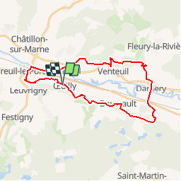
OEUILLY REUIL

bruno38
User

Length
28 km

Max alt
265 m

Uphill gradient
721 m
Km-Effort
37 km

Min alt
61 m

Downhill gradient
726 m
Boucle
Yes
Creation date :
2018-04-17 23:25:57.695
Updated on :
2018-04-17 23:25:57.695
7h55
Difficulty : Medium

FREE GPS app for hiking
 SityTrail
IGN / Geographical institutes
SityTrail Plus
The world is yours!
About
Trail Walking of 28 km to be discovered at Grand Est, Marne, Œuilly. This trail is proposed by bruno38.
Positioning
Country:
France
Region :
Grand Est
Department/Province :
Marne
Municipality :
Œuilly
Location:
Unknown
Start:(Dec)
Start:(UTM)
557772 ; 5435819 (31U) N.
Comments