


HAMARS 18 4 2018

UDGI54
User
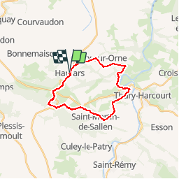

Length
20 km

Max alt
257 m

Uphill gradient
580 m
Km-Effort
28 km

Min alt
29 m

Downhill gradient
584 m
Boucle
Yes
Creation date :
2018-04-17 23:30:33.578
Updated on :
2018-04-17 23:30:33.578
5h00
Difficulty : Unknown

FREE GPS app for hiking
 SityTrail
IGN / Geographical institutes
SityTrail Plus
The world is yours!
About
Trail Other activity of 20 km to be discovered at Normandy, Calvados, Le Hom. This trail is proposed by UDGI54.
Positioning
Country:
France
Region :
Normandy
Department/Province :
Calvados
Municipality :
Le Hom
Location:
Hamars
Start:(Dec)
Start:(UTM)
679444 ; 5430246 (30U) N.
Comments