Trail Walking La Croix-sur-Roudoule - Tête et crêtes de Pibossan en boucle - Photo
© OpenStreetMap contributors
Length
Length
15.2 km
Max alt
Max alt
1617 m
Uphill gradient
Uphill gradient
1048 m
Km-Effort
Km-Effort  
29 km
Min alt
Min alt
716 m
Downhill gradient
Downhill gradient
1050 m
Boucle
Boucle
Yes
Creation date :
2018-04-17 23:32:45.936
Updated on :
2018-04-17 23:32:45.936

(0 Reviews)

Walking
Walking
8h24
Difficulty : Medium

Scan this QR Code to open this trail in the SityTrail application

FREE GPS app for hiking

Logo SityTrail SityTrail

IGN / Geographical institutes

Download SityTrail from the App Store Download SityTrail from Google Play

Logo SityTrail SityTrail Plus

The world is yours!

Download SityTrail from the App Store Download SityTrail from Google Play Download SityTrail on Huawei AppGallery

About

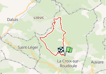
Trail Walking of 15.2 km to be discovered at Provence-Alpes-Côte d'Azur, Maritime Alps, La Croix-sur-Roudoule. This trail is proposed by PEBREJOSIANE.

Description

Départ et Arrivée b 233 route de Léouvé
Cette randonnée nous conduit aux Amarines, Tête de Pibossan, collet Darmelle, Col de Roua, et retour sur les Amarines
1100 m de dénivelé et 5h effectives de marche

Elevation profile

Positioning

Country:
France
Region :
Provence-Alpes-Côte d'Azur
Department/Province :
Maritime Alps
Municipality :
La Croix-sur-Roudoule
Location:
Unknown
Start:(UTM)
329282 ; 4873341 (32T) N.


Close
My subscriptions