


martelange

GANET
User

Length
22 km

Max alt
517 m

Uphill gradient
299 m
Km-Effort
26 km

Min alt
360 m

Downhill gradient
330 m
Boucle
No
Creation date :
2018-04-17 23:33:47.018
Updated on :
2018-04-17 23:33:47.018
2h00
Difficulty : Medium

FREE GPS app for hiking
 SityTrail
IGN / Geographical institutes
SityTrail Plus
The world is yours!
About
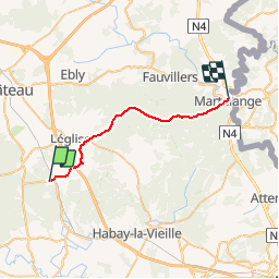
Trail Cycle of 22 km to be discovered at Wallonia, Luxembourg, Léglise. This trail is proposed by GANET.
Description
Martelange
Positioning
Country:
Belgium
Region :
Wallonia
Department/Province :
Luxembourg
Municipality :
Léglise
Location:
Mellier
Start:(Dec)
Start:(UTM)
680856 ; 5515485 (31U) N.
Comments