


angleur . sart tilman . angleur

stef789
User GUIDE
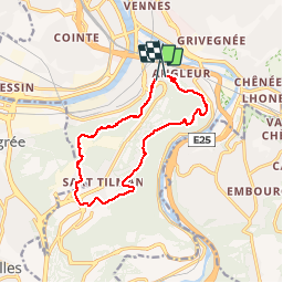

Length
11 km

Max alt
251 m

Uphill gradient
267 m
Km-Effort
14.6 km

Min alt
77 m

Downhill gradient
271 m
Boucle
No
Creation date :
2018-04-17 23:35:38.611
Updated on :
2018-04-17 23:35:38.611
2h18
Difficulty : Easy

FREE GPS app for hiking
 SityTrail
IGN / Geographical institutes
SityTrail Plus
The world is yours!
About
Trail Walking of 11 km to be discovered at Wallonia, Liège, Liège. This trail is proposed by stef789.
Description
montée bois st laurent . descente bois st jacques via streupas
Positioning
Country:
Belgium
Region :
Wallonia
Department/Province :
Liège
Municipality :
Liège
Location:
Angleur
Start:(Dec)
Start:(UTM)
683074 ; 5609802 (31U) N.
Comments