


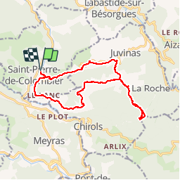
Sainte-Marguerite avec Saint-Pierre de Colombier

raab
User

Length
17 km

Max alt
982 m

Uphill gradient
796 m
Km-Effort
28 km

Min alt
407 m

Downhill gradient
796 m
Boucle
Yes
Creation date :
2018-07-30 16:23:25.336
Updated on :
2018-07-30 16:23:25.368
5h07
Difficulty : Difficult

FREE GPS app for hiking
 SityTrail
IGN / Geographical institutes
SityTrail Plus
The world is yours!
About
Trail Walking of 17 km to be discovered at Auvergne-Rhône-Alpes, Ardèche, Saint-Pierre-de-Colombier. This trail is proposed by raab.
Positioning
Country:
France
Region :
Auvergne-Rhône-Alpes
Department/Province :
Ardèche
Municipality :
Saint-Pierre-de-Colombier
Location:
Unknown
Start:(Dec)
Start:(UTM)
600178 ; 4950907 (31T) N.
Comments