


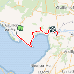
rando pointe de l'aiguilon

dudu85
User

Length
31 km

Max alt
5 m

Uphill gradient
75 m
Km-Effort
32 km

Min alt
-3 m

Downhill gradient
73 m
Boucle
No
Creation date :
2018-04-17 23:50:05.189
Updated on :
2018-04-17 23:50:05.189
3h00
Difficulty : Unknown

FREE GPS app for hiking
 SityTrail
IGN / Geographical institutes
SityTrail Plus
The world is yours!
About
Trail Other activity of 31 km to be discovered at Pays de la Loire, Vendée, L'Aiguillon-sur-Mer. This trail is proposed by dudu85.
Positioning
Country:
France
Region :
Pays de la Loire
Department/Province :
Vendée
Municipality :
L'Aiguillon-sur-Mer
Location:
Unknown
Start:(Dec)
Start:(UTM)
632412 ; 5129905 (30T) N.
Comments