


arcens

raab
User
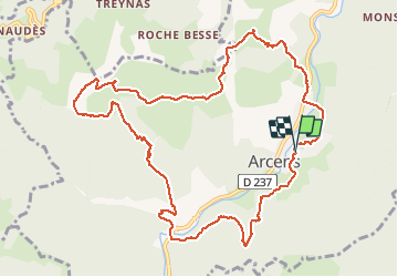

Length
12.9 km

Max alt
1064 m

Uphill gradient
577 m
Km-Effort
21 km

Min alt
607 m

Downhill gradient
574 m
Boucle
Yes
Creation date :
2018-07-30 16:23:25.094
Updated on :
2018-07-30 16:23:25.118
3h38
Difficulty : Easy

FREE GPS app for hiking
 SityTrail
IGN / Geographical institutes
SityTrail Plus
The world is yours!
About
Trail Walking of 12.9 km to be discovered at Auvergne-Rhône-Alpes, Ardèche, Arcens. This trail is proposed by raab.
Positioning
Country:
France
Region :
Auvergne-Rhône-Alpes
Department/Province :
Ardèche
Municipality :
Arcens
Location:
Unknown
Start:(Dec)
Start:(UTM)
604692 ; 4972718 (31T) N.
Comments