


jauldes 35 06042018 roulant

Sergio1664
User
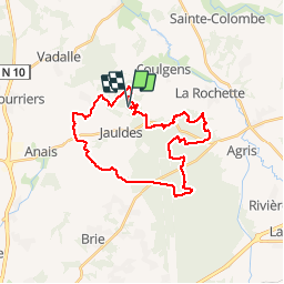

Length
30 km

Max alt
157 m

Uphill gradient
341 m
Km-Effort
34 km

Min alt
79 m

Downhill gradient
341 m
Boucle
Yes
Creation date :
2018-04-17 23:56:12.792
Updated on :
2018-04-17 23:56:12.792
2h39
Difficulty : Easy

FREE GPS app for hiking
 SityTrail
IGN / Geographical institutes
SityTrail Plus
The world is yours!
About
Trail Cycle of 30 km to be discovered at New Aquitaine, Charente, Jauldes. This trail is proposed by Sergio1664.
Positioning
Country:
France
Region :
New Aquitaine
Department/Province :
Charente
Municipality :
Jauldes
Location:
Unknown
Start:(Dec)
Start:(UTM)
287408 ; 5074877 (31T) N.
Comments