


autour du lac de Lavellan

rene06530
User
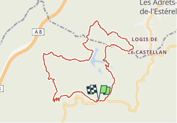

Length
11.4 km

Max alt
353 m

Uphill gradient
479 m
Km-Effort
17.8 km

Min alt
78 m

Downhill gradient
482 m
Boucle
Yes
Creation date :
2018-04-18 00:27:22.192
Updated on :
2018-04-18 00:27:22.192
3h43
Difficulty : Medium

FREE GPS app for hiking
 SityTrail
IGN / Geographical institutes
SityTrail Plus
The world is yours!
About
Trail Walking of 11.4 km to be discovered at Provence-Alpes-Côte d'Azur, Var, Fréjus. This trail is proposed by rene06530.
Description
Départ du Col du Testanier
Positioning
Country:
France
Region :
Provence-Alpes-Côte d'Azur
Department/Province :
Var
Municipality :
Fréjus
Location:
Unknown
Start:(Dec)
Start:(UTM)
321617 ; 4818918 (32T) N.
Comments