


Haid

r.genette
User
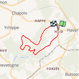

Length
11.3 km

Max alt
320 m

Uphill gradient
196 m
Km-Effort
13.9 km

Min alt
252 m

Downhill gradient
195 m
Boucle
Yes
Creation date :
2018-04-18 00:30:52.15
Updated on :
2018-04-18 00:30:52.15
3h00
Difficulty : Easy

FREE GPS app for hiking
 SityTrail
IGN / Geographical institutes
SityTrail Plus
The world is yours!
About
Trail Walking of 11.3 km to be discovered at Wallonia, Namur, Ciney. This trail is proposed by r.genette.
Description
Très belle balade boisée au départ de la brasserie locale..


Positioning
Country:
Belgium
Region :
Wallonia
Department/Province :
Namur
Municipality :
Ciney
Location:
Serinchamps
Start:(Dec)
Start:(UTM)
655117 ; 5568505 (31U) N.
Comments