


lac de chaumeçon

DaVinci
User
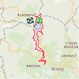

Length
13.5 km

Max alt
406 m

Uphill gradient
120 m
Km-Effort
15.1 km

Min alt
382 m

Downhill gradient
122 m
Boucle
Yes
Creation date :
2018-04-18 00:32:10.431
Updated on :
2018-04-18 00:32:10.431
2h42
Difficulty : Unknown

FREE GPS app for hiking
 SityTrail
IGN / Geographical institutes
SityTrail Plus
The world is yours!
About
Trail Other activity of 13.5 km to be discovered at Bourgogne-Franche-Comté, Nièvre, Brassy. This trail is proposed by DaVinci.
Positioning
Country:
France
Region :
Bourgogne-Franche-Comté
Department/Province :
Nièvre
Municipality :
Brassy
Location:
Unknown
Start:(Dec)
Start:(UTM)
568888 ; 5238129 (31T) N.
Comments