


but st genis

guyzinz
User
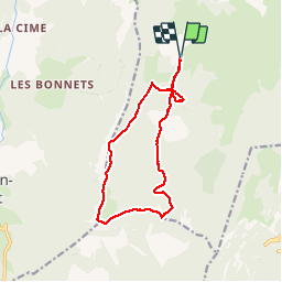

Length
13.4 km

Max alt
1619 m

Uphill gradient
535 m
Km-Effort
21 km

Min alt
1170 m

Downhill gradient
536 m
Boucle
Yes
Creation date :
2019-06-07 09:39:05.924
Updated on :
2019-06-07 09:39:06.049
4h16
Difficulty : Unknown

FREE GPS app for hiking
 SityTrail
IGN / Geographical institutes
SityTrail Plus
The world is yours!
About
Trail Walking of 13.4 km to be discovered at Auvergne-Rhône-Alpes, Drôme, Vassieux-en-Vercors. This trail is proposed by guyzinz.
Positioning
Country:
France
Region :
Auvergne-Rhône-Alpes
Department/Province :
Drôme
Municipality :
Vassieux-en-Vercors
Location:
Unknown
Start:(Dec)
Start:(UTM)
686233 ; 4970762 (31T) N.
Comments