


Etape 2 vers Côte Normande Acquigny (Louviers) vers Normandie

lionelwalter
User
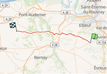

Length
59 km

Max alt
174 m

Uphill gradient
384 m
Km-Effort
65 km

Min alt
42 m

Downhill gradient
466 m
Boucle
No
Creation date :
2018-04-18 00:42:11.264
Updated on :
2018-04-18 00:42:11.264
3h45
Difficulty : Easy

FREE GPS app for hiking
 SityTrail
IGN / Geographical institutes
SityTrail Plus
The world is yours!
About
Trail Cycle of 59 km to be discovered at Normandy, Eure, Venon. This trail is proposed by lionelwalter.
Description
Etape 2 vers Côte Normande passage par le Bec Helloin, jusqu'à Cormeilles (Pays d'Auge)
Positioning
Country:
France
Region :
Normandy
Department/Province :
Eure
Municipality :
Venon
Location:
Unknown
Start:(Dec)
Start:(UTM)
358466 ; 5449070 (31U) N.
Comments